| Location | El Salvador |
|---|---|
| Sponsors | U.S. National Weather Service-International Activities Office (NWS/IAO) and the U.S. Agency for International Development/Bureau for Humanitarian Assistance (USAID/BHA) |
| Authors | Dr. Rochelle Campbell (HRC) and Celina Kattan (Senior Consultant) |
| Collaborators | Daniel Beardsley (NOAA); Robert Jubach (HRC); Jacqueline Rivera (MARN); Adriel Renderos (MARN); Roberto Cerón (MARN); Carolina Rivas (MARN) y Mauricio Martinez (MARN). |
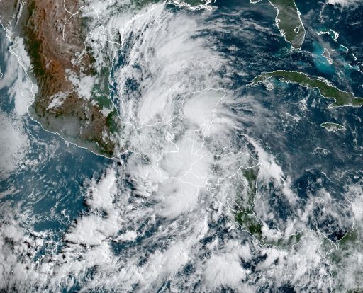
Tropical Storm Amanda, the first named storm of the 2020 Pacific hurricane season, formed at 09:00 UTC on 31 May 2020, a few kilometers off the coast of Guatemala and El Salvador, and made landfall just three hours later in southeastern Guatemala, bringing torrential rainfall and cascading multiple-hazards, numerous landslides and major urban flash flooding to El Salvador. The remnants of Amanda then reorganized and strengthened near the Yucatán Peninsula into Tropical Storm Cristobal and continued to produce heavy rainfall across Central America through 7 June 2020. The rainfall event produced by Tropical Storms Amanda and Cristobal was the second most significant precipitation event in the history of El Salvador, with the highest storm total rainfall report of 1087.1 mm (Volcán Conchagua station, La Unión), behind only Tropical Depression 12E in October 2011 (1513 mm) and well above Hurricane Mitch’s total rainfall report of 861 mm in October 1998. Reported tropical-storm-force wind gusts in El Salvador were 95 km/hr (Berlin station, Usulután).
The storms occurred at the start of the rainy season when soils were still dry, and water levels in rivers and reservoirs were low. So pre-existing hydrometeorological conditions were highly influential in moderating secondary hazards such as floods and landslides. Most impacts were associated with the intense and torrential rainfall that occurred at the beginning of the event, leading to significant urban flooding across the Metropolitan Region of San Salvador and flash floods along the smaller river basins that respond more quickly and directly to intense precipitation. The passage of Tropical Storms Amanda and Cristobal resulted in 30 direct deaths in El Salvador and five in Guatemala, nearly 600,000 people affected, and significant damage to main roads and infrastructure.
People-centered early warning systems helped reduce impacts on life and property. An example is the Central America Flash Flood Guidance (CAFFG), used to produce hazard forecasts that become impact-based projections with exposure and vulnerability information. These events occurred as El Salvador had reached the implementation phase of the Weather Ready Nations program (WRNs), a multi-hazard impact-based forecasting and early warning approach to provide accurate and easily understandable information and deliver decision support services. The program had helped the National Meteorological and Hydrologic Services increase close collaboration with National Disaster Management Agencies and other stakeholder agencies and partners, which was fundamental to increasing trust and enabling early action and response.
As in many countries, the COVID-19 pandemic added unforeseen complexity to response measures, limiting first responders’ capacities and increasing the perceived risk associated with the expected protective actions, such as preventive evacuations. Early warning systems need to be adapted to consider compounding risks and their systemic nature, as the long-lasting effects of the COVID-19 crisis on the underlying factors of vulnerability and risk continue.