| Location: | Indonesia |
|---|---|
| Authors: | Rion Suaib Salman (BMKG), Rochelle Campbell (HRC), Celina Kattan (Senior Consultant) |
| Publication/Conference Presentation: | 1st WMO/WWRP "Weather and Society" Conference 2022, Oral Presentation |
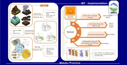
High-impact hydrometeorological events, particularly floods and landslides, are hazardous events that give rise to multiple casualties and significant damage to property and infrastructure. From these events, impacts on development in Maluku Province, Indonesia, are further exacerbated due to noticeable increases in extreme rainfall events attributable to a changing climate. While conventional weather forecasts focus on meteorological thresholds for extreme events, Impact-Based Forecasts (IBF) integrate information about the potential severity of weather impacts with their likelihood of occurrence. As IBF provides an indication of local risk, there is increasing uptake of this approach globally. Recognizing the vulnerability of the Maluku Province to severe weather and the potential benefits of such a risk-based approach for informing disaster risk reduction, Badan Meteorologi Klimatologi dan Geofisika (BMKG) has implemented a Weather-Ready Nations approach in 2018 with the support of the U.S. National Weather Service-International Activities Office and the U.S. Agency for International Development/Bureau for Humanitarian Assistance, in partnership with the Hydrologic Research Center. To demonstrate the value of IBF for stakeholders, the Maluku province office overlaid weather forecasts with flood and landslide hazard and risk information. For Maluku Province, impact-based forecasts are developed using basic tools in ArcMap at a District and Sub District level. Flood risk and landslide risk information for the province was digitized and Geographic Information Systems (GIS) were used to convert all layers of data to a standard format, overlay them and classify the outputs according to the expected impact levels. The IBF layout contains all the information that stakeholders and users need, such as impact area, expected societal impacts, and recommended actions. Geography Information System (SIG) and geospatial analysis tools facilitate the development of weather forecasters’ impact-based forecasts.